
DJI MATRICE 400
Engineered for Excellence, Designed for Versatility
From $10,479 CAD
DJI Matrice 400, the enterprise flagship drone platform, boasts an impressive 59-minute flight time [1], a payload capacity of up to 6 kg [2], and integrated rotating LiDAR and mmWave radar for power-line-level obstacle sensing [3]. It also supports the O4 Enterprise Enhanced Video Transmission and Airborne Relay Video Transmission [4], ensuring safer handling and easier operations. Combining Smart Detection with visible and thermal imaging, AR projection, ship-based takeoff/landing, and advanced automation, Matrice 400 excels in emergency response, power inspections, mapping, and AEC.


Extended Flight Time, High Speed Performance
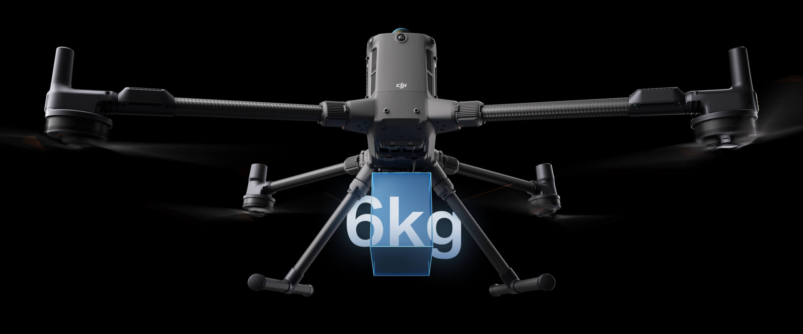
Up to 6kg Payload Capacity
Safe and Reliable Flight
Enhanced Intelligence and Efficiency
Automated Operations
Comprehensive Accessory Upgrades
DJI Care Enterprise
Extended Flight Time, High Speed Performance
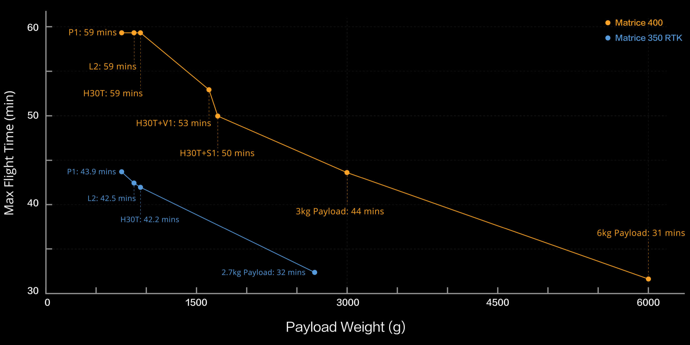
Matrice 400's flight capabilities are outstanding, offering up to 59 minutes of forward flight time even with a payload, and up to 53 minutes of hovering duration [6]. These capabilities make it a reliable tool for long-duration and continuous operations such as search and rescue, firefighting, and large-scale mapping. It can also avoid large obstacles [3] like buildings and mountains at flight speeds of up to 25 m/s.
Up to 59 Mins
Forward Flight Time
Up to 25 m/s
Flight Speed
Multi-Payload, Multi-Scene
Matrice 400’s strong payload capacity allows it to easily meet the demands of a wide range of applications. With a maximum payload capacity of 6 kg [2], Matrice 400 supports seamless switching between a single downward gimbal [8] and a dual downward gimbal [8]. It also features a third gimbal connector on the underside for additional flexibility. The aircraft is equipped with 4 external E-Port V2 ports [7], enabling simultaneous mounting of up to 7 payloads.
Depending on the task, Matrice 400 can be equipped with the Zenmuse H30 Series, L2, P1, S1 Spotlight, V1 Speaker, Manifold 3, or third-party payloads, thereby expanding its capabilities and unlocking the full potential of the DJI ecosystem.
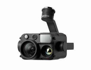
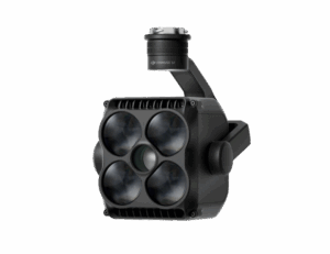
Zenmuse H30 Series
The Zenmuse H30 Series integrates five major modules—a wide-angle camera, a zoom camera, an infrared thermal camera, a laser range finder, and an NIR auxiliary light. Employing cutting-edge intelligent algorithms, it revolutionizes perception and imaging standards, transcending the limitations of day and night vision.
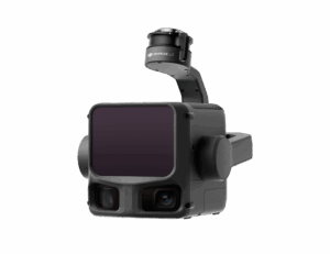
Zenmuse L3
Zenmuse L3 features a 1535nm long-range LiDAR, dual 100MP RGB mapping cameras, and a high-precision POS system. It can be mounted on Matrice 400 using the Zenmuse L3 single gimbal connector, accelerating geospatial data acquisition.
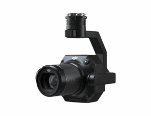
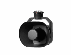
Zenmuse P1
Zenmuse P1 integrates a full-frame sensor with interchangeable fixed-focus lenses on a 3-axis stabilized gimbal. Designed for photogrammetry flight missions, it takes efficiency and accuracy to a whole new level.
Zenmuse S1
Zenmuse S1 is DJI’s first spotlight designed for multi-payload drone platforms. Utilizing the LEP technology, it offers high brightness and long illumination distance, and supports multiple lighting modes. This makes it ideal for public safety, emergency rescue, inspection, and other nighttime operations.
Zenmuse V1
Zenmuse V1 is DJI’s first loudspeaker designed for multi-payload drone platforms. It boasts high volume and long broadcast distance, and supports multiple broadcast modes, making it ideal for scenarios like public safety, emergency rescue, and more.
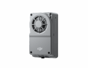
Manifold 3
Manifold 3 packs an impressive 100 TOPS of computing power into a compact unit weighing about 120 g. It can be mounted onto Matrice 400 drone platform, optimizing efficiency across various operational missions with its robust processing.
Flight Time
Estimate the Matrice 400’s flight time based on payload configuration.
Safe and Reliable Flight
Built for Challenging Conditions
Matrice 400 has a protection rating of IP55 [9], allowing it to operate reliably in challenging conditions including heavy dust or rain. It also maintains stable performance across temperatures from -20° to 50° C (-4° to 122° F), delivering consistent results in both hot and cold conditions.
IP55
IP Rating
-20° to 50° C (-4° to 122° F)
Operating Temperature
Power-Line-Level Obstacle Sensing
The Matrice 400's advanced obstacle sensing system integrates rotating LiDAR, high-precision mmWave radar, and full-color low-light fisheye vision sensors [13], pushing detection capabilities to unprecedented levels. The system detects even small obstacles like high-voltage power lines across mountainous terrain — even in darkness [3]. It can penetrate rain and fog to sense its surroundings, providing enhanced safety in challenging weather conditions.
Robust Video Transmission
O4 Enterprise Enhanced Video Transmission System
Thanks to the ten-antenna system on the aircraft and the high-gain phased array antenna system on the remote controller, the O4 Enterprise Enhanced Video Transmission System can achieve image transmission up to 40 km [10].
Matrice 400 also supports the sub2G frequency band [5], and when equipped with two DJI Cellular Dongle 2 [11], it can automatically switch to the better available carrier network, providing a more stable signal even in urban interference environments or remote regions.
Airborne Relay Video Transmission
Matrice 400 has a built-in video transmission relay module. With this setup, one Matrice 400 can serve as a relay drone, flying high to provide relay signals for another Matrice 400 operating at a greater distance. This capability significantly extends the transmission range, making it ideal for search and rescue tasks as well as inspections in mountainous areas.
Aircraft Fusion Positioning
The omnidirectional sensing performance [12] brought by rotating LiDAR, high-precision mmWave radar, and full-color low-light fisheye vision sensors provides Matrice 400 with strong positioning capabilities. It can fly stably close to glass-facade buildings or wind turbine blades and safely return from building edges, mountain bases, or bridge sides even when the return point has not been updated.
Full-Color Vision Assist
The four full-color low-light fisheye vision sensors on the aircraft provide Full-Color Vision Assist [13] to ensure safer flight.
Comprehensive Accessory Upgrades
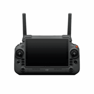
DJI RC Plus 2 Enterprise Enhanced
DJI RC Plus 2 Enterprise Enhanced Remote Controller features a new high-brightness screen that remains clearly visible even in direct sunlight. It has an IP54 protection rating and can operate in temperatures ranging from -20° to 50° C (-4° to 122° F). Equipped with the O4 Enterprise Enhanced Video Transmission, it features a built-in high-gain antenna array, providing strong performance. It also supports the sub2G module and 4G hybrid transmission solutions, ensuring stable and smooth video feeds in both urban high-rise and mountainous environments.
DJI Cellular Dongle 2
The DJI Cellular Dongle 2 offers 4G network video transmission and can work together with the O4 Enterprise Enhanced Video Transmission System, ensuring safe flights in complex environments. Additionally, it provides mobile network connectivity for the remote controller.
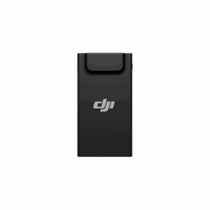
TB100 Battery
The TB100 Intelligent Flight Battery uses high-performance, high-energy cells and can be charged up to 400 cycles, reducing the cost per flight. It also features enhanced heat dissipation and is equipped with a self-heating system for improved reliability.
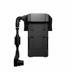
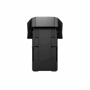
TB100C Tethered Battery
The TB100C Tethered Battery is compatible with third-party tethered lighting and communication products, enabling long-duration aerial lighting and communication base station functions via cable. Reserved ports are available to support third-party development of automated recharging station products, such as drone docks.
BS100 Intelligent Battery Station
The intelligent battery station is a one-stop solution for battery charging, storage, and transport. It can charge up to three TB100 batteries and two WB37 batteries sequentially. With a fast charging time of just 45 minutes [18] per TB100 battery, it ensures seamless, uninterrupted flight operations. In Silent Mode, noise levels are as low as 36 dB [19].
D-RTK 3 Multifunctional Station
The D-RTK 3 Multifunctional Station can serve as a base station to provide centimeter-level positioning for multiple drones simultaneously. Additionally, the new Rover Station Mode, combined with the DJI Enterprise app and DJI Terra, provides a comprehensive solution for high-precision aerial surveying applications, ensuring accurate operations.
Application Scenarios
Public Safety
Power Line Inspection
Geographic Information
Oil and Gas
Renewable Energy
Roads and Bridges
Maritime
Water Conservation
Get In Touch
Have a question? Ready for a quote?
We’re here to help! Reach out to us today.
Specs
Takeoff Weight (with propellers)
Without Batteries: 5020 ± 20 g
With Batteries: 9740 ± 40 g
The actual product weight may vary due to differences in batch materials and external factors.
Max Takeoff Weight
15.8 kg
Dimensions
Unfolded: 980 × 760 × 480 mm (L × W × H) (with landing gear)
Folded: 490 × 490 × 480 mm (L × W × H) (with landing gear and gimbal)
Maximum dimensions excluding propellers.
Aircraft carrying case dimensions: 779 × 363 × 528 mm (L × W × H)
Max Payload
6 kg
The 6 kg payload is measured at the third gimbal connector under sea level conditions. Payload capacity decreases as altitude increases. For details, refer to the official user manual.
Propeller Size
25 inches
Diagonal Wheelbase
1070 mm
Max Ascent Speed
10 m/s
Max Descent Speed
8 m/s
Max Horizontal Speed (at sea level, no wind)
25 m/s
Max Takeoff Altitude
7000 m
Max Flight Time (no wind)
59 minutes
Measured with the aircraft flying forward at a constant speed of 10 m/s in a windless environment at sea level, carrying only the H30T (total weight 10,670 g), and from 100% battery level until 0%. Data is for reference only. Actual experience may vary depending on the environment, usage, and firmware version.
Max Hover Time (no wind)
53 minutes
Measured with the aircraft hovering in a windless environment at sea level, carrying only the H30T (total weight 10,670 g), and from 100% battery level until 0%. Data is for reference only. Actual usage time may vary depending on the flight mode, accessories, and environment.
Max Flight Distance (no wind)
49 km
Measured by the aircraft flying forward at a constant speed of 17 m/s in a windless environment at sea level, without external payloads, and from 100% battery level until 0%. Actual experience may vary depending on the environment, usage, and firmware version.
Max Wind Speed Resistance
12 m/s
Max wind speed resistance during takeoff and landing.
Max Yaw Angular Velocity
Yaw: 100°/s
Max Pitch Angle
35°
Operating Temperature
-20° to 50° C (-4° to 122° F) (without solar radiation)
Global Navigation Satellite System (GNSS)
GPS + Galileo + BeiDou + GLONASS*
GLONASS is supported only when the RTK module is enabled.
Equipped with standard airborne ADS-B In receiver and dual antennas, supporting reception up to 20 km.
Hovering Accuracy Range (with moderate or no wind)
Vertical:
±0.1 m (with vision positioning)
±0.5 m (with satellite positioning)
±0.1 m (with RTK positioning)
Horizontal:
±0.3 m (with vision positioning)
±0.5 m (with satellite positioning)
±0.1 m (with RTK positioning)
RTK GNSS Accuracy
RTK Fix: 1 cm + 1 ppm (horizontal), 1.5 cm + 1 ppm (vertical)
RTK Heading
Supports RTK heading with an accuracy better than 2°
Airborne ADS-B In
Equipped with standard airborne ADS-B In receiver and dual antennas, supporting reception up to 20 km.
Internal Storage
N/A
Ports
USB-C Debug Port × 1: USB 2.0
E-Port V2 × 4: At the lower part of the drone, with 120 W single-port power
Cellular Dongle 2 Interface × 2: On the underside of the drone
Propeller Model
2510F
Beacon
Built into the aircraft
Ingress Protection Rating
IP55
The rating is not permanently effective and may decrease due to product wear and tear.
Motor Model
7510
Maximum Payload for Single Gimbal Connector
1400 g
If exceeded, the gimbal damper lifespan will decrease from 1000 hours to 400 hours.
Maximum Payload for Dual Gimbal Connector
950 g
Maximum Payload for Third Gimbal Connector
3 kg for quick-release port, 6 kg for screw lock fastening
Sensing Type
Omnidirectional binocular vision system (surround view provided by full-color fisheye vision sensors)
Horizontal rotating LiDAR, upper LiDAR, and downward 3D infrared range sensor
Six-direction mmWave radar
Forward
Measurement Range: 0.4–21 m
Detection Range: 0.4–200 m
Field of View (FOV): 90° (horizontal), 90° (vertical)
Backward
Measurement Range: 0.4–21 m
Detection Range: 0.4–200 m
Field of View (FOV): 90° (horizontal), 90° (vertical)
Lateral
Measurement Range: 0.6–21 m
Detection Range: 0.5–200 m
Field of View (FOV): 90° (horizontal), 90° (vertical)
Downward
Measurement Range: 0.5–19 m
The FOV to the front and rear is 160° and 105° to the right and left.
Operating Environment
Forward, Backward, Left, Right, and Upward:
Delicate texture on the surface, adequate light.
Downward:
The ground has rich textures and sufficient lighting conditions*, with a diffuse reflection surface and a reflectivity greater than 20% (such as walls, trees, people, etc.).
Sufficient lighting conditions refer to an illuminance not lower than that of a nighttime city light scene.
Rotating LiDAR
Standard Measurement Range: 0.5–100 m @ 100,000 lux with 10% reflectivity target
Measurement Range for Power Line: 35 m @ 30° @ 10,000 lux for 21.6 mm steel-core aluminum stranded wire with a relative body tilt angle of 30° to the left and right
Field of View (FOV): 360° (horizontal), 58° (vertical)
Point-Frequency: 520,000 points/second
Laser Wavelength: 905 nm
Eye Safety Level: Class 1 (IEC60825-1:2014), eye-safe
Upper LiDAR (3D ToF)
0.5–25 m at night (reflectivity > 10%)
The FOV to the up and down is 60° and 60° to the right and left.
Downward 3D Infrared Range Sensor
Measurement Range: 0.3–8 m (reflectivity > 10%)
The FOV to the front and rear is 60° and 60° to the right and left.
mmWave Radar
Measurement Range for Power Line:
36 m for a 12.5 mm steel-core aluminum stranded wire
50 m for a 21.6 mm steel-core aluminum stranded wire
FOV: ±45° (horizontal and vertical)
The mmWave radar function is unavailable in some countries/regions.
Resolution
1080p
Field of View (FOV)
DFOV: 150°
HFOV: 139.6°
VFOV: 95.3°
Frame Rate
30fps
Night Vision
Starlight Grade
Video Transmission System
DJI O4 Enterprise Enhanced Video Transmission System
Live View Quality
Remote Controller: 3-channel 1080p/30fps
Operating Frequency and Transmitter Power (EIRP)
902–928 MHz: < 30 dBm (FCC), < 16 dBm (MIC)
1.430–1.444 GHz: < 35 dBm (SRRC)
2.4000–2.4835 GHz: < 33 dBm (FCC), < 20 dBm (CE/SRRC/MIC)
5.150–5.250 GHz: < 23 dBm (FCC/CE)
5.725–5.850 GHz: < 33 dBm (FCC), < 14 dBm (CE), < 30 dBm (SRRC)
Operating frequency allowed varies among countries and regions. Refer to local laws and regulations for more information.
Max Transmission Distance (unobstructed, free of interference)
40 km (FCC)
20 km (CE/SRRC/MIC)
Measured in an unobstructed environment free of interference. The above data shows the farthest communication range for one-way, non-return flights under each standard. During your flight, please pay attention to RTH reminder on the DJI Pilot 2 app.
Max Transmission Distance (with interference)
Strong interference (dense buildings, residential areas, etc.): approx. 1.5–6 km
Medium interference (suburban counties, city parks, etc.): approx. 6–15 km
Weak interference (open spaces, remote areas, etc.): approx. 15–40 km
Data is tested under FCC standard in unobstructed environments of typical interference. Only to serve as a reference and provides no guarantee as to the actual flight distance.
Max Download Speed
Standard Mode: 80 Mbps Downlink
Playback Download: < 25 MBps
Single-Channel Bitrate: ≤ 12 Mbps
The above data was measured under conditions where the aircraft and remote controller were in close proximity without interference.
Antenna
WLAN Antenna × 8: 6 vertically polarized antennas and 2 horizontally polarized antennas
sub2G Antenna × 2: 2 vertically polarized antennas
4G Antenna × 4
Operating Mode: 2T4R
Others
Supports Dual Control Mode and 2-channel Cellular Dongle 2
Stabilization System
DJI Matrice 4T: 3-axis (tilt, roll, pan)
DJI Matrice 4E: 3-axis (tilt, roll, pan)
Mechanical Range
DJI Matrice 4T
Gimbal Mechanical Limits
Tilt: -140° to 113°
Roll: -52° to 52°
Pan: -65° to 65°
Soft Limits
Tilt: -90° to 35°
Roll: -47° to 47°
Pan: -60° to 60°
DJI Matrice 4E
Gimbal Mechanical Limits
Tilt: -140° to 50°
Roll: -52° to 52°
Pan: -65° to 65°
Soft Limits
Tilt: -90° to 35°
Roll: -47° to 47°
Pan: -60° to 60°
Controllable Rotation Range
DJI Matrice 4T
Tilt: -90° to 35°
Pan: Not controllable
DJI Matrice 4E
Tilt: -90° to 35°
Pan: Not controllable
Max Control Speed (Tilt)
100°/s
Angular Vibration Range
±0.007°
Yaw Axis
Manual operation is uncontrollable
The MSDK interface program is controllable
Ingress Protection Rating
No Standard Protection Level
Operating Temperature
Standard: -10°C to 40°C (14°F to 104°F)
Sensing Type
Omnidirectional binocular vision system, supplemented with a 3D infrared sensor at the bottom of the aircraft.
Forward
Binocular Measurement Range: 0.4–22.5 m
Measurement Range: 0.4–200 m
Obstacle Avoidance Speed: Flight Speed ≤ 21 m/s
FOV: 90° (horizontal), 135° (vertical)
Backward
Measurement Range: 0.4–22.5 m
Measurement Range: 0.4–200 m
Obstacle Avoidance Speed: Flight Speed ≤ 21 m/s
FOV: 90° (horizontal), 135° (vertical)
Lateral
Measurement Range: 0.5–32 m
Measurement Range: 0.5–200 m
Obstacle Avoidance Speed: Flight Speed ≤ 21 m/s
FOV: 90° (horizontal), 90° (vertical)
Downward
Measurement Range: 0.3–18.8 m
Obstacle Avoidance Speed: Flight Speed ≤ 10 m/s
The FOV to the front and rear is 160°, and 160° to the right and left.
Operating Environment
Forward, Backward, Left, Right, and Upward:
Delicate texture on the surface, adequate light.
Downward:
The ground has rich textures and sufficient lighting conditions*, with a diffuse reflection surface and a reflectivity greater than 20% (such as walls, trees, people, etc.).
*Sufficient lighting conditions refer to an illuminance not lower than that of a nighttime city light scene.
O4 Enterprise
Live View Quality
Remote Controller: 1080p @ 30fps
Operating Frequency
2.400–2.4835 GHz
5.725–5.850 GHz
5.150–5.250 GHz (CE)
Operating frequency allowed varies among countries and regions. Refer to local laws and regulations for more information.
Transmitter Power (EIRP)
2.4 GHz: ≤ 33 dBm (FCC), ≤ 20 dBm (CE/SRRC/MIC)
5.8 GHz: < 33 dBm (FCC), < 30 dBm (SRRC), < 14 dBm (CE)
5.15–5.25 GHz: < 23 dBm (FCC/CE)
Max Transmission Distance (unobstructed, free of interference)
25 km (FCC)
12 km (CE)
12 km (SRRC)
12 km (MIC)
Measured in an unobstructed environment free of interference. The above data shows the farthest communication range for one-way, non-return flights under each standard. During your flight, please pay attention to RTH reminders in the DJI Pilot 2 app.
Max Transmission Distance (with interference)
Strong Interference – City Centers: approx. 1.5–5 km
Medium Interference – Suburban Areas: approx. 5–15 km
Micro Interference – Suburbs/Seasides: approx. 15–25 km
Data tested under FCC standards in unobstructed environments with typical interference. For reference only — not a guarantee of actual flight distance.
Max Download Speed
20 MB/s
Measured under close-proximity, interference-free conditions.
Latency
130 ms
Under near-field interference-free conditions when shooting with a 1x lens.
Antenna
8 antennas, 2T4R
Others
Cellular Dongle Compartment
Model
TB100
Capacity
20254 mAh
Standard Voltage
48.23 V
Max Charging Voltage
54.6 V
Cell Type
Li-ion 13S
Energy
977 Wh
Weight
4720 ± 20 g
Charging Temperature
5° to 45° C (41° to 113° F)
Discharging Temperature
-20° to 75° C (-4° to 167° F)
Battery Heating
Single Battery: Support
Onboard: Support
Battery Station: Support
Discharge Rate
4C
Max Charging Power
2C
Low-Temperature Charging
Supports low-temperature self-heating charging
Cycle Count
400
Model
BS100
Net Weight
11.8 kg
Dimensions
605 × 410 × 250 mm (L × W × H)
Supported Batteries
TB100 Intelligent Flight Battery, TB100C Tethered Battery, WB37 Battery
Operating Temperature
-20° to 40° C (-4° to 104° F)
Input
100–240 V (AC), 50–60 Hz, 10 A
Output
USB-C:
5.0 V 3.0 A, 9.0 V 3.0 A, 12.0 V 3.0 A, 15.0 V 3.0 A, 20.0 V 3.25 A
TB100 Battery Interface:
100–110 V: Approx. 1185 W
110–180 V: Approx. 1474 W
180–240 V: Approx. 2184 W
WB37 Battery Interface:
100–240 V: Approx. 52 W
Number of Charging Channels
Three TB100 and two WB37 batteries
Charging Mode
Ready-to-Fly Mode 90%; Standard Mode 100%
Supports Fast Charging Mode and Silent Mode
Charging Time
TB100/TB100C Battery From 0% to 100%:
220 V: 45 minutes (Fast Charging Mode); 110 minutes (Silent Mode)
110 V: 70 minutes (Fast Charging Mode); 110 minutes (Silent Mode)
Charging time is measured in a test environment with a temperature of 25° C.
Video Transmission System
DJI O4 Enterprise Enhanced Video Transmission System
Max Transmission Distance (unobstructed, free of interference)
40 km (FCC)
20 km (CE/SRRC/MIC)
Measured in an unobstructed environment free of interference. The above data shows the farthest communication range for one-way, non-return flights under each standard. During your flight, please pay attention to RTH reminder on the DJI Pilot 2 app.
Video Transmission Operating Frequency and Transmitter Power (EIRP)
902–928 MHz: < 30 dBm (FCC), < 16 dBm (MIC)
2.400–2.4835 GHz: < 33 dBm (FCC), < 20 dBm (CE/SRRC/MIC)
5.150–5.250 GHz: < 23 dBm (FCC/CE)
5.725–5.850 GHz: < 33 dBm (FCC), < 14 dBm (CE), < 30 dBm (SRRC)
Operating frequency allowed varies among countries and regions. Refer to local laws and regulations for more information.
Antenna
2T4R, 2.4GHz/5.8GHz multi-beam high-gain antenna
sub2G Module: 2T2R
Enhanced Transmission
Supports DJI Cellular Dongle 2
Wi-Fi Protocol
Wi-Fi Direct, Wireless Display, IEEE 802.11 a/b/n/ac/ax
Supports 2×2 MIMO Wi-Fi, dual-band simultaneous (DBS) support for dual MAC, with data rates up to 1774.5 Mbps (2×2 + 2×2 11ax dual-band simultaneous)
Wi-Fi Operating Frequency
2.4000–2.4835 GHz
5.150–5.250 GHz
5.725–5.850 GHz
5.2 and 5.8 GHz frequencies are prohibited in some countries. In some countries, the 5.2 GHz frequency is only allowed for use indoors.
Wi-Fi Transmitter Power (EIRP)
2.4 GHz: < 26 dBm, < 20 dBm (CE/SRRC/MIC)
5.1 GHz: < 23 dBm (FCC/CE/SRRC/MIC)
5.8 GHz: < 23 dBm (FCC/SRRC), < 14 dBm (CE)
Bluetooth Protocol
Bluetooth 5.2
Bluetooth Operating Frequency
2.400–2.4835 GHz
Bluetooth Transmitter Power (EIRP)
< 10 dBm
Screen Resolution
1920 × 1200
Screen Size
7.02 inches
Screen Frame Rate
60fps
Brightness
1400 nits
Touchscreen Control
10-Point Multi-Touch
Built-in Battery
2S2P High Energy Density 18650 Lithium-ion Battery (6500 mAh @ 7.2 V) 46.8 Wh
External Battery
Optional, WB37 (4920 mAh @ 7.6 V) 37 Wh
Charging Type
Supports PD fast charging, with a maximum 20V/3.25A USB Type-C charger
Storage Capacity
RAM 8G + ROM 128G UFS + expandable storage via microSD card
Charging Time
2 hours for internal battery; 2 hours for internal plus external batteries
When remote controller is powered off and using a standard DJI charger.
Internal Battery Runtime
3.8 hours
External Battery Runtime
3.2 hours
Output Port
HDMI 1.4
Indicators
Status LED, battery level LED, connection status LED, tricolor light, brightness adjustable according to ambient light
Speaker
Supports buzzer
Audio
Array MIC
Operating Temperature
-20° to 50° C (-4° to 122° F)
Storage Temperature
Within one month: -30° to 45° C (-22° to 140° F)
One to three months: -30° to 35° C (-22° to 113° F)
Three months to one year: -30° to 30° C (-22° to 86° F)
Charging Temperature
5° to 40° C (41° to 104° F)
Supported Aircraft Model
Matrice 400
Global Navigation Satellite System
GPS + Galileo + BeiDou
Dimensions
268 × 163 × 94.5 mm (L × W × H)
Width including external antenna folded, thickness including handle and controller sticks.
Weight
1.15 kg (without external battery)
Model
TKPL 2
System Version
Android 11
External Interfaces
HDMI 1.4, SD 3.0, USB-C with OTG support, max 65W PD charging, USB-A with USB 2.0 support
Accessories
Strap/waist support
DJI Products Compatible With Matrice 400
Gimbal Cameras:
Zenmuse H30, Zenmuse H30T, Zenmuse L2, Zenmuse P1
Accessories:
Zenmuse S1 (drone spotlight), Zenmuse V1 (drone speaker), Manifold 3, DJI RC Plus 2 sub2G SDR Module, DJI Cellular Dongle 2
RTK Station:
D-RTK 3 Multifunctional Station, D-RTK 2 Mobile Station
Ecosystem Accessories:
DJI X-Port
DJI E-Port V2 Development Kit
DJI E-Port V2 Coaxial Cable Kit
DJI SKYPORT V3 Adapter Set
DJI SKYPORT V3 Coaxial Cable Kit